Acquire
During the acquisition process, many technically challenging activities are happening at the same time, often in remote and environmentally sensitive areas. These activities are costly and time-sensitive, increasing the pressure for all parties involved.
Acquiring seismic data is complex - equipment failure, installation issues and operator error can lead to erroneous data, or worst case, no data at all. Our specialist personnel, software, and quality control processes assure that the data you expect is the data you get.
Every seismic project is led by an experienced project manager. They collaborate with the multiple technical teams at RPS as needed during the acquisition phase to assure a successful project while reducing inefficiencies, optimising the acquisition plan and meeting all health, safety and environmental regulations.
We deliver pragmatic solutions, providing confidence at every stage of a seismic project.
Our expertise
Mitigating the risks to marine mammals and other protected species is crucial to a successful seismic project. RPS had deep expertise in providing mitigation solutions including Protected Species Observers (PSOs), also known as Marine Mammal Observers (MMOs), and Passive Acoustic Monitoring (PAM).
These observers use visual observation and passive acoustic monitoring to ensure geophysical acquisition is conducted following mitigation measures. This team reports to the lead representative and a dedicated RPS onshore environmental project manager. The observers and operators provide real-time observations and retain up-to-date records of marine mammal statistics during the course of the seismic program.
Acoustic specialists
The specialists in the acoustics team at RPS have extensive knowledge and experience in assessing the potential impact of seismic surveys on marine life including marine mammals, fish, shellfish and turtles. Our underwater noise survey, impact assessment, modelling and control skills can assess and identify ways to mitigate the high noise levels that can disturb or injure marine life. Our underwater noise propagation models use peer-reviewed methodologies combined with detailed source modelling to account for the complex effects associated with underwater sound propagation. We have worked closely with regulators and their advisors as well as operators and developers to develop a robust assessment style in line with relevant guidance and regulations.
Services include:
- underwater acoustic modelling;
- assessing the effects of seismic surveys on marine life
- seismic source array selection and gun modelling
- sound source verification (SSV) surveys.
Unexploded Ordnance (UXO) and Explosive Remnants of War (ERW) specialists
Protecting people and assets economically, effectively and efficiently presents specific challenges when assessing and addressing the risks of Unexploded Ordnance (UXO), Explosive Remnants of War (ERW), landmine, explosives and Chemical Warfare Agents (CWA).
The explosives engineering team at RPS use their deep expertise to provide informed advice and deliver the most appropriate and cost-effective service to manage the threats associated with ordnance contamination, on- and offshore. We are pragmatic in our approach to mitigating UXO, ERW and other risks, delivering project specific solutions to meet our clients’ needs.
Oceanographic specialists
The metocean, science and technology team at RPS supports our clients with a depth of understanding of the ocean and the challenges measuring, predicting, operating and managing it that can only be gained through decades of experience and continuous improvement.
With a breadth of services from the most challenging metocean measurement, leading-edge data analysis and management, quantitative environmental impact prediction and class-leading software and web technologies, it is not hard to see why.
Air and water quality specialists
Our comprehensive range of proprietary modelling software supports a wide variety of work including strategic research and development, environmental impact assessments, sediment and pollutant transport studies, storm surge forecasting, sea level rise and flood risk assessments, offshore engineering design, port and harbour design, maritime safety, coastal process simulation, and scheme design. With our team's expert knowledge of the complex ocean environment and the modelling methods that represent it, we provide efficient in-house solutions to help realise successful projects for our clients.
Contingency Planning
Our oceanographers, data specialists, and modellers tackle a range of scenarios from oil spill response to search and recovery of assets and saving lives at sea. We train and assist clients in developing efficient response plans for a variety of challenging emergencies.
Spill trajectory modelling
RPS have developed deep expertise in the assessment of risk and the potential for damage from unplanned releases of oil and other hydrocarbons into the marine environment. This is critical for the planning and permitting of new assets and developments, and to responding to real world spill events such as Macondo, Montara, Bohai Bay and the Shen Neng. Through hundreds of detailed risk assessment studies, many real-world spill response applications and the continuous development of our peer reviewed and validated software solutions, we provide an unparalleled capability in support of our clients.
Clients have been relying on RPS to provide in-country support during their acquisition projects for over 40 years. RPS' in-country project supervisors are our clients' eyes and ears on the ground. They act on behalf of our clients to ensure the project runs smoothly and safely.
Our in-country project supervisors identify and manage project risks, and support the development of project plans, environmental management plans, hazard identification (HAZID) workshops, operational meetings and reporting. The supervisor leads the health, safety and environmental (HSE) management system field audits. They coordinate with other project specialists, including marine auditors. They are based in the country of operations and have extensive interaction with our client's country manager, HSE and operations teams. The supervisors perform field visits in support of planning, stakeholder engagement and operations. They attend the crew start-up meeting, crew changes, mid-project reviews and project closeout meetings. Working closely with the seismic contractor's onshore support personnel, they ensure adherence to our client's policies and standards and assist with logistical support.
RPS' in-country project supervisors are the field representatives first point of contact for health, safety, environment and security (HSES) support. Demonstrating excellence in HSE leadership, they actively push the crew for continuing improvement and adherence to our client's policies and standards, environment management plan, and any country regulations. They monitor the seismic contractor's HSE and operational systems to ensure their efficacy throughout the survey.
Other areas of supervision are journey management. In the event of a medical emergency, they assume first responder responsibilities and support medical evacuation response planning (MERP). They review all incidents, technical and HSES, and participate in formal reviews and incident investigations. Working closely with client HSES teams, they ensure all worksite personnel have been inducted into the HSES requirements for the project.
The supervisor reviews all reports for accuracy and oversees the timely delivery of information to the operations manager, seismic acquisition manager, company country manager and other stakeholders. Deliverables include tracking daily production against the plan, reviewing contractor invoices, highlighting potential issues, reviewing with the onboard team, operations manager and seismic acquisition manager.
As needed, the in-country project supervisor assists the company country manager with stakeholder engagement. On land surveys, it is common for the project supervisor to make regular visits to the field crew.
Confirmation that suitable equipment and workflows are in place to reliably and accurately coordinate and process acquisition points and nodes is vital to ensure the spatial integrity of any acquired data whether an operation is onshore or offshore. Geodetic and positioning audits verify a contractor's ability to deliver a spatially accurate and cost-effective acquisition project, while ensuring final products can be reliably integrated with any existing data.
RPS offer a tailored approach for the QA/QC of spatial data accumulated during the acquisition phase of any project ensuring all generated data and deliverables are fit for purpose. From pre-planning operations, field scouting, hazard mapping and legacy data verification through to the final loading of the received data, RPS can cater a support service to ensure a quality product is acquired and delivered.
Additionally, RPS geomatics experts perform First Line Quality Control (FLQC) services providing enhanced seismic navigation QC checks of marine seismic operations. Offshore, we have conducted contractor audits on Shearwater GeoServices, Polarcus, and CGGVeritas amongst others and we perform processing and quality control of marine seismic (2D and 3D) navigation data using our custom Sirius/Neptune software and third-party NorthStarGeo Geometis MX and SP software packages.
Other audits include:
- aviation audits
- maritime audits
- safety management system audit
Open communication between ocean and land usage stakeholders is critical to ensuring seismic surveys are completed safely and cost-effectively with minimal disruption to all parties.
RPS' clients benefit from our decades of experience supporting organisations to understand the environmental, social and governance (ESG) impact of their operations, and we foster vital project buy-in. RPS works on behalf of operators to engage with community stakeholders to explain the proposed activities and identify, understand and list to issues and concerns. RPS establishes trust and builds mutual relationships with project stakeholders. This includes engagement with fishers, farmers and other landowners to ensure their concerns are understood, and mutually beneficial relationships are built. Drawing on engagement, economics, sustainability and research principles, we provide objective third-party reviews of project and organisational policies, procedures and management systems, evaluate potential risks and uncover opportunities for better management, community engagement, governance and more. Our global team of ESG professionals enhance our clients’ investments through strategies, processes and policies that satisfy the expectations of the communities in which they operate.
Seismic projects are both technically and commercially complex. Once begun, these projects must deliver the data quality required, within the project budget, safely and without incident. RPS' technical, commercial, and field management team represent your interests, making complex easy.
All team members assist with project planning and participate in start-up meetings, operational meetings, post-project lookback sessions, coordinate collection of lookback lessons learned and best practices, and contribute to daily and the comprehensive final acquisition report.
Lead quality control representative
The lead quality control (QC) representative acts as team lead to all representatives and as offshore / in-field contact for the contractor's party manager. They are aware of all activities and guide the other representatives. They report directly to the client project manager. The role includes monitoring operational activities and ensuring concurrence with the project time and activity allocations, operational priorities, site-specific and management plans. The lead QC representative monitors work conducted within exclusion zones, attends toolbox talks associated with close-pass operations and they participate in incident investigation and reporting data collection if required.
The lead QC supervisor is in charge of a team that may include another seismic QC supervisor, HSE supervisor, positioning QC, data processing QC, drilling QC (on land), and environmental supervisor. The lead QC will be responsible for submitting to the client a comprehensive final report on the seismic contractor's performance at the end of the project.
Seismic quality control representative
The seismic quality control (QC) representative assesses the geophysical contractor's technical procedures and processes, the technical integrity of seismic data and reports to the lead representative and the client's technical counterpart. They also monitor and assess the technical integrity of the geophysical data acquired during field operations. The seismic QC performs audits to assess compliance with contract requirements, as well as against regulatory and industry standards. They also provide technical input regarding data acquisition methodology, equipment and parameter selection. Also, the seismic QC verifies that the geophysical contractor and subcontractor adhere to the technical and operational procedures and requirements. They monitor the geophysical contractor and subcontractors for contractual compliance concerning personnel, equipment, expendables, logistical supplies, and quality of equipment. They monitor all operational activities while ensuring concurrence with the site-specific management plan and with specific responsibility for geophysical quality control. They provide, where appropriate, and utilise quality control and verification software to assess the performance of acquisition and positioning systems. The QC represents the client in project related technical matters and submits comprehensive daily reports on all aspects of seismic quality control.
On a land survey, the QC supervisor will be responsible for overseeing all field operations of the seismic crew – survey, line clearance, shot-hole drilling, recording, up-hole / low velocity layer (LVL) data acquisition, crop compensation and land restoration.
The QC supervisor may also be involved in mentoring and advising acquisition contractor and oil company personnel. Their duties may include liaison with local stakeholders and government officials, particularly on land projects.
Navigation/positioning quality control representative
The navigation/positioning quality control (QC) representative assesses the geophysical contractor's navigation and positioning procedures and workflows, and the technical/spatial integrity of navigation data acquired during onshore/offshore operations. RPS works closely with the contractor, client and other QCs to protect the client's best interests. We ensure any spatial data generated during the project is reliable and adequately defined. We verify that the contractor maintains compliance with contract requirements, along with any regulatory and industry standards. Where appropriate, the QC provides quality control and verification software to independently assess the performance of positioning systems and they provide technical input regarding positioning equipment, methodology and data processing to ensure your expectations are maintained.
On a land project, the survey QC also works closely with the crew surveyors to ensure that the line location avoids unnecessary source or receiver skips. They also work with the contractor's QC seismologist to plan the most effective management of any skips.
RPS tailors project-specific QA/QC support service to ensure a quality product is acquired and delivered that meets expectations and suits budgetary requirements. With fit for purpose QA/QC monitoring, either from the field or carried out remotely, operations run smoothly and provide the client with an opportunity to have relevant and considered input as the project progresses.
Seismic processing geophysicist
In cases where data is being fast track processed in the field, the client may require an infield processing geophysicist to oversee this work.
Technical auditor
A technical audit is an independent assessment of seismic technical systems, procedures and methods. The auditor is an engineer equipped to examine and test the contractor's equipment using independent measuring devices and software. The technical audits are typically offshore / in-field up to initial system field deployment and testing. On a land crew, the technical audit will include an assessment of the seismic energy sources, (vibrators or explosives), receivers and any secondary recording systems used for LVL or up-hole studies.
Health, safety and environmental (HSE) advisor
The HSE advisor monitors the operational activities with the primary responsibility of ensuring compliance with the client’s management system and geophysical contractor HSE procedures and processes. Their role is to observe and support geophysical contractor and subcontractor HSE systems.
The advisors role includes:
- providing strong mentorship
- coaching and leadership
- interacting with geophysical contractor onboard HSE advisor
- delivering various HSE initiatives that will enhance workforce HSE culture
- contributing to achieving incident and injury-free operations
- maintaining accurate, up-to-date records of HSE statistics and leading/lagging indicators for daily and weekly report
- compiling, assessing and conveying HSE information to the client, including incident reporting data and photographs
- performing and/or participating in onboard health, environmental and safety audits or inspections and incident investigations
- compiling and submitting daily and weekly activity, observations and HSE statistics
- actively contributing to HSE based guidance to onboard operations
- influencing safe behaviors and recommending preventative or corrective actions
- promoting, participating and visibly supporting all project HSE initiatives
- communicating clients' HSE objectives, strategies and expectations to the workforce
- monitoring the geophysical contractor’s management of identified hazards and action items
- consistently applying risk management concepts and principles and hazard identification and mitigation techniques.
Seismic support is most economical and safest when delivered onshore, instead of in the field or on the vessel. RPS operates a platform of tools to enable real-time information to be collected on seismic operations and to support remote oversight, management, monitoring and quality control. Our investment in people and technology and our pragmatic approach to project management means we support clients' projects anywhere in the world from anywhere in the world.
Making complex easy.
Real-time survey management
The key to allowing the quality control (QC) of a survey from any location is to house the data into the cloud. RPS has developed Osprey online with Drop and Display cloud-enabled technology which allows the technical specialists to work either infield or from the shore. The Osprey suite of technologies can be configured to perform remote data management, with direct integration online and to the underlying ArcGIS database. The specialists then access the survey data through the online system anywhere in the world.
Osprey Drop and Display Cloud-Enabled Technology
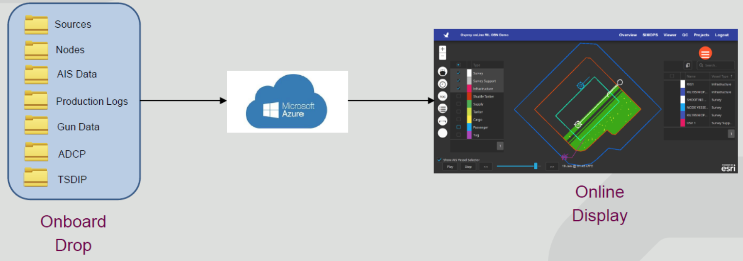
Osprey Drop and Display Cloud-Enabled Technology allow the user to pre-configure the project requirements needed for the oversight and QC of the project. The following are available online:
- Project overview and progress
- Pseudo-real-time vessel tracking
- Navigation attributes (maps and time series)
- Source/Near Field Hydrophone attributes (maps and time series)
- Coverage and repeatability
- Contract compliance and exception highlighting
- Simultaneous operations ( SIMOPs) visualisation
Real-time commercial management
RPS manages seismic projects commercial performance using seismic project management and reporting databases systems which are fully integrated and synchronised for all project users irrespective of location. These tools allow customers to have direct access to the latest information on project performance, including safety, environmental, technical and commercial 24/7 anywhere in the world.
Real-time environmental management
RPS has been at the forefront of real-time measurement and analysis of protected species observation information worldwide for over ten years. RPS have tested, deployed, and proven communication systems which enable the transmission of large digital data sets from project sites offshore to onshore for real-time analysis and decision making.
Real-time integrity management
RPS capabilities extend to tools which actively monitoring the health of critical marine components while taking into account environmental data, including both real-time observations and model forecasts. These are integrated into the physics-based models that form the digital twin of the asset within NeoSight, allowing fatigue and integrity assessment using the measured and predicted conditions experienced onsite.
Artificial intelligence (AI) and project management
RPS continues to test the applications of AI and to find ways to improve project efficiencies. RPS has expertise in AI and Project Management, and we have applied AI to a diverse range of projects from environmental assessments to water treatment systems. RPS delivers training on Time Lapse (4D) seismic data in field development, including the use of artificial intelligence. We apply data management, analysis and insight and collect, manage and disseminate big data for clients across the globe to deliver operational efficiencies and unlock complex business information.
Key contacts

Tony LaPierre
Technical Director - Seismic Operations and Site Investigations

Roger Edgecombe
Director Energy Operations - AAP
No Content Set
Exception:
Website.Models.ViewModels.Blocks.PageBlocks.CardBlocks.RelatedProjectCardBlockVm

