

Define
Seismic surveys take significant capital and require people to work in challenging environments. Well defined surveys assure the technical objectives are met, and the survey is efficient, saving costs and minimising project risk.
Our expertise
Environmental licensing
Seismic projects have the potential to significantly affect the environment and local communities. In an increasingly populated and resource constrained world, understanding the relationships between people and the built and natural environments is more important than ever.
Applying an information-led approach to environmental consulting, utilising state-of-the-art technologies including visualisation, spatial intelligence and dynamic scenario modelling, we shape informed decisions so that these projects balance the technical, social and environmental with responsible economic outcomes. Our deep expertise working in the energy industry for over 40 years ensures we’re the team to deliver the right solutions - making complex easy.
Our services include;
Regulatory affairs
Commitment to environmental protection is fundamental in the exploration and development of natural resources. We support our clients in ensuring compliance throughout a project’s lifecycle verifications, permits and reporting.
With in-depth technical knowledge, gained through decades of global experience, we deliver environmental modelling, risk and impact assessments and provide hands-on support at every stage. From the project’s outset, we can advise on easily integrating all aspects of your activities with regulatory and sustainable development objectives.
Services include:
- Land and marine permitting
- Social license assessments
- Local benefits development plans
Tender technical support
Setting the technical specifications for acquisition contractors during the bidding processing is crucial for acquiring the quality of data necessary, in a manner that is safe and cost-effective. Our experienced geophysical specialists provide deep expertise in developing tender documentation together with sound knowledge of the various contractors that are capable of participating in the tender process.
An important component of the draft acquisition contract is the technical specifications. It also must cover such topics as health and safety, environmental, recording standards, positioning, survey planning, and in-field processing.
To make the tender process easier, we respond to requests for clarification from bidders. We analyse the responses and guide our clients through the selection process. We evaluate criteria such as;
- Earliest mobilisation date
- Anticipated rates of production and duration of project
- Methodology and technical innovation
- Equipment supplied
- Project cost
- Previous regional experience
- Health, safety and environment record
- Local content
Once bids are received, we create comprehensive financial models to effectively evaluate multiple tenders Project costs are calculated and compared for differing sets of acquisition parameters to inform the decisions making process.
Once a contractor is determined, our technical specialists review contract appendices to ensure that the specifications are appropriate for the work and up-to-date. They review agreement to ensure that it is fit for purpose and includes the necessary clauses to avoid ambiguity once the work commences.
Our services include;
- Bid assessment
- Technical specification
- Bid development
- Tender evaluations
- Processing specifications
- Seismic data delivery standards
Geomatics - geodesy, positioning, GIS and earth observation
Whether operations are onshore or offshore, navigation and positioning is an essential component in ensuring optimum quality seismic data. Everything must be in the correct place to get reliable data. Any geodetic parameters adopted to acquire new data must be clearly defined with connections with legacy datasets verified. Old and new datasets must stack up precisely in layers to maintain the geospatial integrity of an asset throughout the exploration and production life cycle.
By analysing available GIS datasets, relevant earth observation data and from field scouting and legacy project information, considered and detailed project planning, hazard mapping, and geodetic assessment of the spatial aspects of a project can be carried out before any survey commences. By identifying potential complications early, plans can adapt, and mitigation procedures can be established during the survey design and ahead of operations commencing rather than wasting time in the field.
Onshore at the start of and during operations, surveyors provide positioning/survey control audits along with data QC and legacy data verification. The surveyor monitors survey operations and audits equipment and procedures and ensures that all spatial data is correctly populated in any seismic trace/header information or other spatial data exchange formats generated. Geodetic specialists can rectify any errors uncovered by a geodetic audit where there are issues between the use of local and earth centred satellite derived datums. Offshore, experienced navigation QC personnel, using onboard QC systems running in parallel with the contractor's system, deliver real-time QC and verification of navigation integrity.
Office-based navigation QC processing provides an additional layer of assurance that the technical objectives of the survey are being met. Our geomatics experts receive the positioning data daily and process them in-house, verifying that all P1 and P2 datasets are correct and that all parameters are in conformance with contractual requirements. We can also take old seismic navigation data sets and verify the integrity of data before reprocessing or integration with new data.
From pre-planning operations, field scouting, hazard mapping and legacy data verification through to the final loading of the received data, RPS tailors a geomatics support service to cover the entirety of the project lifecycle with the aim that data is delivered to meet expectations and requirements.
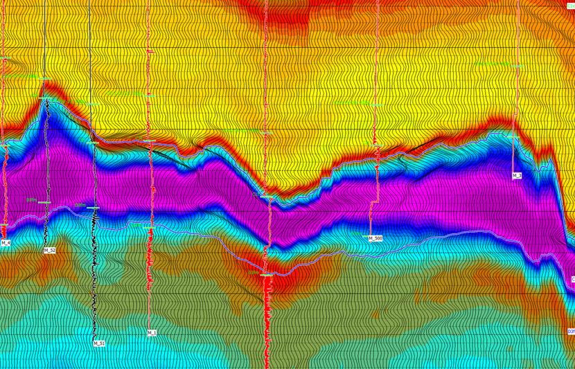
Seismic survey design
Ensuring that a seismic survey is fully optimized is imperative for the success of any exploration or development project. Our survey design strategy takes a pragmatic approach and combines both geophysical and logistical considerations with innovation and integrated thinking. In this way, the optimum survey is designed at the beginning of any exploration or development project, balancing cost and quality. RPS has delivered seismic survey design services for over 30 years and has a deep level of expertise in 2D, 3D, 4D, land, marine, ocean bottom, TZ and borehole projects worldwide.
Seismic survey design services include:
- Survey evaluation and design
- Seismic design services
- Seismic feasibility studies
- Seismic illumination studies
- Survey planning
- Seismic modelling
- Seismic processing studies
Seismic technology assessments
RPS delivers seismic technology assessments for marine, land and borehole seismic projects. RPS is entirely independent of all seismic contractors. Technology assessments are part of our integrated seismic project management services. We understand that seismic technologies are deployed to optimize reservoir management and resource extraction. 4D seismic data is integral to highlighting permeability pathways, identifying reservoir compartmentalization, and locating unproduced oil and gas, and reducing well placement uncertainty.
Seismic data is therefore key to increased efficiencies in offshore drilling and production.
We complete over 100 contractor performance studies and audits annually. This experience is from the direct engagement of RPS professionals in the field. It allows RPS to understand the capabilities of the seismic contractors and aids in planning for future operations.
Services include:
- Contractor capability assessments
- Market assessments
- Tow capability assessments
- Budget planning
Constraints assessments
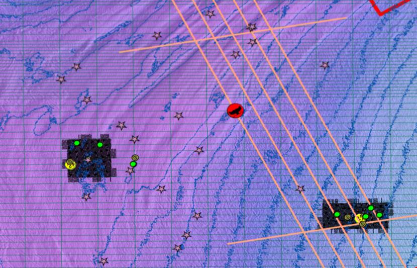
RPS performs constraint assessment and mitigation planning in support of seismic operations. These constraints can be temporal and spatial, including:
- archaeological
- biological
- environmental
- geohazards
- oceanographic
- socioeconomical
- infrastructure
- terrain
- local content
- national boundaries
- permits
- logistical
- safety and security
During planning, RPS seismic project managers map out project constraints and develop mitigations for each project based on our field experience, and the expertise of our environmental scientists, geospatial specialists, using measurement and modelling technologies.
Environmental Constraints/Mitigation
RPS scientists have diverse backgrounds and expertise in marine biology, habitat and community ecology, and biological and physical oceanography. We bring a unique understanding of both the physical environment and the impacts and mitigation of potential stressors on species across trophic levels (plankton, benthic/epibenthic invertebrates, pelagic and demersal fish, shellfish, marine mammals, sea turtles, seabirds).
RPS have deep expertise in:
- Protected species monitoring and mitigation for industry and academia
- Writing incidental harassment authorizations
- Licensing and compliance
- Interpretation of requirements of conservation legislation
- Environmental assessment, compliance auditing, consenting, licensing and permitting
- Provision of statutory and regulatory advisory services to competent authorities including government departments and bodies
- Permitting/consenting processes support and contributing to government documents (EA, EIS);
- Design and implementation of monitoring plans
- Mitigation design and ecological compensation
Physical Oceanographic Constraints
In the marine environment the primary physical forces acting on the project to create constraints are currents, winds, and waves. RPS can help clients plan surveys to reduce the impact of these forces on their projects.
RPS metocean scientists have over 40 years in metocean measurement and modelling and have developed RPS OceansMap. This tool provides for the ability to access, visualize, and interpret a broad range of environmental data from around the globe, including both real-time observations and model forecasts.
The OceansMap web portals combine sophisticated data visualization and analysis tools with an intuitive, map-based interface designed to facilitate data exploration and discovery. Users can query sources to access data simply by clicking an icon on the map. These data can then be visualized using embedded tools to create everything from scatter plots to stunning, map-based animations, or characterized quantitatively using a variety of integrated analytical tools.
OceansMap is a leading tool for maritime planning including operational search-and-rescue.
Logistical and Security Constraints
RPS delivers seismic projects around the globe. We have worked in over 150 countries. The ability to safely move people to and from remote locations is key to the delivery of services to our clients.
Our logistics team manages travel risk, using in-depth analysis and assessment of developing situations as well as on ongoing threats and trends. We arrange for visas/work permits to ensure travellers meet all country specific entry requirements. We confirm certification and arrange training to ensure everyone meets certification and medical clearance requirements specific to the job. All travel arrangements, journey management and security briefings are managed by RPS’ logistic team. This team use International SOS as a tracking tool intended for the rapid reaction to any emerging security threat using its alerting and communication services and monitoring ongoing international security issues.
The specialists on your project get safely to your locations and at the end of each rotation, safely home.
Marine assurance
Many vessel inspection reports fail to adequately identify real areas of risk. This can include costly operational delays from postponed maintenance, poor implantation of safety procedures and fines for non-compliance.
Independent, third party marine vessel audits can identify gaps in the understanding of the true risk, determine systems adequacy and a vessel’s ‘fit for purpose’ work status and develop effective procedures for improvement.


Meet the team
-

-

-

David O'Hara
Senior Vice President
-

-

Nicola Simpson
Director of Offshore Renewables, EAME; Director of Marine Consenting & Environment, EAME.
Learn more -

Related services


Key contacts

Tony LaPierre
Technical Director - Seismic Operations and Site Investigations

Roger Edgecombe
Director Energy Operations - AAP