
Deliver
The goal of every seismic acquisition project is a data set that provides precise information about the features and the potential for natural resources below the earth’s surface.
Significant investments are made to collect seismic data, but for it to be valuable, it must be correctly processed, loaded, hosted and interpreted. Complex data sets and data fields need to match during imports and uploads. Errors not discovered immediately, wreak havoc – to fix them wastes time, but not finding them at all is disastrous. RPS data technicians have processed hundreds of surveys. Using specialised software and workflows, they assure that our clients’ data is worry-free and ready to use on delivery.
Seismic processing
RPS has an extensive range of associates around the world with data processing expertise and with experience in all types of data processing environments and techniques.
Delivering
- Functional expertise in data processing
- Independent analysis and advice
- Clear communication of the technical objectives and requirements for all stakeholders
RPS provides experienced seismic data processing consultants for all acquisition environments, for reprocessing projects, processing of newly acquired data and 4D processing. Offshore and on-crew processing quality control (QC) is also provided infield or remotely. Our processing personnel work seamlessly with our navigation and source modelling specialists to help ensure rapid turnaround times and define optimum quality data.
Data Processing Supervision and Management
The increasing complexity of geology being explored is mirrored in data processing, velocity model building and imaging choices available within the market. Seismic processing requires a growing amount of specialist knowledge and integration data. RPS has seismic processing specialists familiar with all stages of data processing projects for marine, land and ocean bed seismic (OBS). Our experienced team define the ideal processing sequence for your data to ensure the best possible value for money. RPS has provided support to seismic data processing projects for over 30 years. We have a worldwide team of experienced personnel engaged in land, marine and transition zone projects.
Tailored In-House processing projects
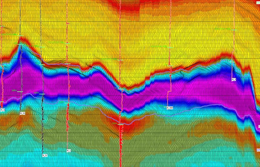
Tailored in-house processing projects benefit from direct interaction between the interpreter and the seismic processing specialist. These projects can include focused reprocessing over a well location or target, evaluation of reprocessing potential, survey merge, augmentation of prior processing or data conditioning for amplitude variation with offset (AVO) and inversion studies. Processing techniques that often provide a quick uplift include bandwidth extension, additional multiple removal, well synthetic match and use of structural tensors for fault resolution. We have the in-house expertise and software to undertake projects from field data to pre-stack time migration at a prospect level that many specialist processing companies find too small to offer competitive pricing. For larger projects, we recommend the supervision and management of data processing.
Services include:
- Post processing refinement for improved interpretation clarity
- Bandwidth extension
- Residual migration
- Survey/Well match
- Re-datum or re-grid for survey or project merge
- Residual demultiple or migration
- Post stack depth conversion
- Full processing from disk transcripts of field data for small 2D and 3D volumes
- SEGD / SEGY merge with SPS or UKOOA
- Marine Full denoise/demultiple/de-ghosting sequence
- Land 5D and cross-spread processing, statics investigations.
- Kirchhoff pre-stack time migration and post-stack depth conversion.
- Reprocessing evaluation studies for subsets of larger volumes
- Field data evaluation
- Synthetic modelling
- Data conditioning for inversion studies
- AVO gradient analysis
- Generation of seismic attribute volumes
Crew Processing
Crew Processing has developed with increasing computer power and software capability into an industry-standard tool to generate quick-look volumes or to ‘fast-track’ final processing. This approach helps monitor the suitability of parameters over diverse terrain and allows near real-time decisions on data coverage to be made. This is an area that we have worked on since on-crew processing first became a possibility, and we frequently provide experienced personnel to help ensure that the best possible quality is obtained.
Advanced seismic data analysis
RPS provides advanced data analysis on seismic data including
- Technical advice for both processing and analysis, and review of existing geophysical studies
- Log editing, petrophysical analysis, well ties, wavelet extraction and wavelet processing
- AVO forward modelling based on well data or regional information
- AVO screening using standard attributes (Intercept, Gradient, Scaled Poisson’s ratio and Fluid Factor) and prospect generation
- Coloured inversion
- Model-based post-stack inversion to acoustic impedance (AI)
- Simultaneous pre-stack model-based inversion to acoustic impedance and shear impedance
- Subsequent reformulation of results to Vp/Vs, Poisson’s ratio, Lambda-Rho and Mu-Rho
- Band-limited and full bandwidth EI and EEI inversions for discreet partial angle stacks and Chi angle rotations
Data and reporting
RPS has supported our clients on thousands of seismic projects worldwide over the last 40 years. Central to each project is the delivery of technical reports and project databases. These document the field operations, quality assurance, quality control processes and findings. RPS maintains a digital reporting library and provides secure storage and access of these technical documents for future use.
The RPS reports are prepared with great care, easy to use and reflect the importance RPS places on documenting the work performed for our clients, including the steps and findings which have gone into ensuring project success. RPS seismic reports fully document the survey operations and services delivered onsite. They provide a full appraisal of all survey elements (timing and production, performance appraisal, position quality control, equipment and systems, seismic data quality control, vessel and crew, HSE performance and all aspects of environmental project management).
The reports provided are a valuable product which can provide guidance for subsequent work on the data such as seismic processing or in planning future seismic operations. They are essential business documents, detailing time, production and record-keeping for our clients. These can assist in contractual negotiations and decision making by clients on current and future projects.
Data loading integrity
Geospatial auditing
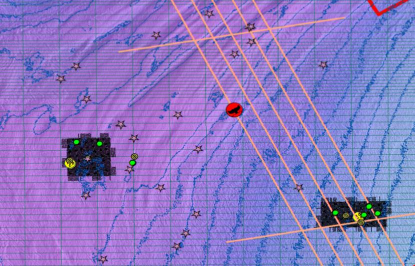
RPS’ geomatics specialists ensure data is correctly positioned when seismic data is loaded into client data repositories, mitigating against costly errors, and time wasting regularly caused by explorationists interpreting spatially misplaced data. RPS assists in setting up a quality assurance (QA) data management workflow for spatial data. The workflow ensures no matter where data is accessed along the exploration and production (E&P) value chain and with what software, data users have the ability to verify and therefore trust the data they are evaluating.
The RPS geomatics team carries out forensic analysis of data sets to verify the integrity of and to resolve spatial issues related to incorrect and incomplete boundary definitions, seismic data, well positions and other E&P related data. RPS has supported spatial verification work for many operators, including work on international and license boundary delineations and has regularly been commissioned to audit clients seismic and well databases and interpretation projects.
Legacy seismic data
The seamless integration of recently acquired project data with any legacy E&P data is important in safeguarding business decisions based on interpretation projects with mixed vintage datasets. It is important for explorationists to be able to verify and trust the spatial component of any data accessed along the E&P value chain. RPS geomatics experts can carry out assessments on the reliability of any spatial data throughout the O&G lifecycle used in the decision-making process. Additionally, RPS has specialists experienced in positioning, reprocessing and correction of legacy navigation formats (P180, P190, SPS, P286, P294) to current P111 and P211 formats.
Data hosting
In RPS’ PSO Map we host company-specific libraries which provide real-time access to secure, global protected species observer data and reports, including access to generalized data-set of all historical protected species detections.
In RPS Osprey, we host all elements of completed seismic projects in client accessible libraries including all vessel automatic identification systems.