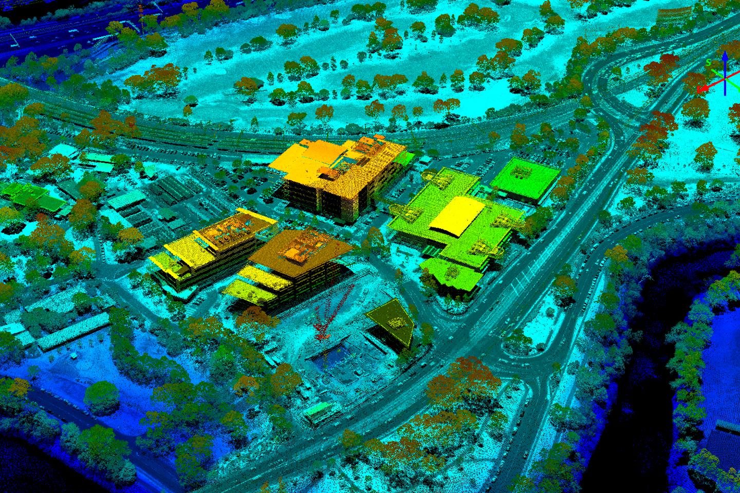
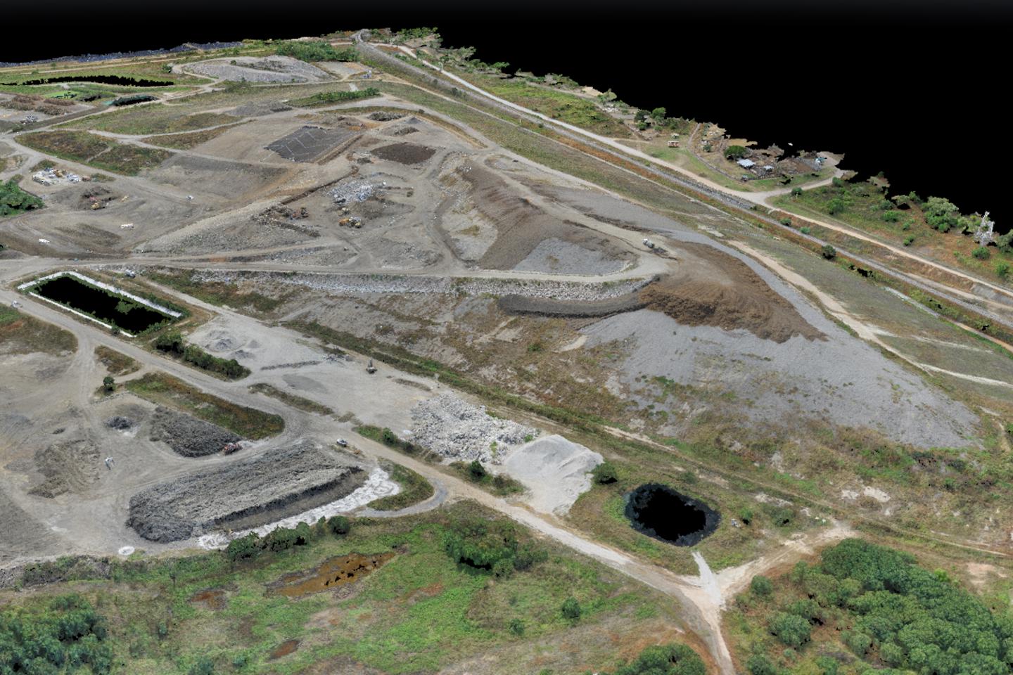
Aerial LiDAR and photogrammetry survey
Light Detection and Ranging (LiDAR) is method of mapping that allows high levels of detail to be recorded about topography, vegetation, buildings, infrastructure, and more.
No Content Set
Exception:
Website.Models.ViewModels.Components.General.Banners.BannerComponentVm
Services
Technical services and consulting solutions for clients in the property, energy, transport, water, resources, defence and government sectors.
Advisory and management consulting
Communications, creative and digital
Design and development
Environment
Exploration and development
Health, safety and risk
Laboratories
Oceans and coastal
Planning and approvals
Project and program management
Training
Water services
Advisory and management consulting
RPS advisory and management consulting services for businesses and projects, including economics, due diligence, transaction advisory, ESG and more.
Communications, creative and digital
Communications, creative and digital solutions for governments and businesses including community engagement, design, research, data and software development.
Design and development
Technical and consulting services for buildings, infrastructure and cities including architecture, engineering, surveying, landscape architecture and urban design.
Environment
Environmental consulting solutions for responsible, resilient and sustainable development including impact assessment, ecology and contamination management.
Exploration and development
Technical services for energy projects including seismic operations, drilling and wellsite geology, reservoir management, independent reporting and more.
Health, safety and risk
From safety case development to emergency response strategy, discover services and expertise to reduce your risk profile and keep people safe.
Laboratories
Scientific analysis services for AgroScience, food safety, workplace exposure, environmental analysis and contaminants of concern in Europe and the UK.
Oceans and coastal
RPS technical solutions for marine infrastructure and offshore development including coastal engineering, marine biology metocean science, and emergency response.
Planning and approvals
Development strategy, planning and approval solutions for buildings, infrastructure, transport and city projects and investments.
Project and program management
Project management solutions for the most complex building, infrastructure, organisational change, and systems projects.
Training
Specialist training services, programs and accreditation for health, safety and risk, project management, and energy sector capability development.
Water services
Solutions for the water sector including quality monitoring, modelling, infrastructure design, engineering and asset management.
Sectors
World-leading technical and consulting solutions for clients in the property, energy, transport, resources, water, defence and government sectors.
Property
Energy
Transport
Defence and government services
Water
Resources
Property
Design, technical and advisory services for the property sector, including residential, commercial, retail, industrial, health, education and data centre projects.
Energy
Energy exploration, development and optimisation solutions for renewables, power and gas networks, energy storage, oil and gas and nuclear facilties.
Transport
Smart, safe and sustainable transport infrastructure development services and advice for rail, aviation, port and road clients and projects.
Defence and government services
Expertise for defence capability and infrastructure investments, security and safety projects, and information and telecommunications initatives.
Water
Discover our industry-leading strategy, design and management solutions for wastewater, groundwater, flooding, drainage and network infrastructure.
Resources
Commercial data, design advice and technical management solutions for safe and environmentally responsible resource exploration and operations.
Technical services and consulting solutions for clients in the property, energy, transport, water, resources, defence and government sectors.
Advisory and management consulting
Communications, creative and digital
RPS advisory and management consulting services for businesses and projects, including economics, due diligence, transaction advisory, ESG and more.
Project investment and finance
Business strategy and improvement
Explore Advisory and management consultingCommunications, creative and digital solutions for governments and businesses including community engagement, design, research, data and software development.
Creative, visualisation and immersive design
Data management, analytics and insights
Software design and implementation
Explore Communications, creative and digitalTechnical and consulting services for buildings, infrastructure and cities including architecture, engineering, surveying, landscape architecture and urban design.
Environmental consulting solutions for responsible, resilient and sustainable development including impact assessment, ecology and contamination management.
Acoustics, noise and vibration
Contaminated land and remediation
Environmental Impact Assessment
Environmental permitting and compliance
Sustainability and climate resilience
Explore EnvironmentTechnical services for energy projects including seismic operations, drilling and wellsite geology, reservoir management, independent reporting and more.
Asset and reservoir management
Drilling support and wellsite geology
Field development planning and operations
Reserves and independent reporting
Seismic operations management and support
Exploration and appraisal studies
Unitisation and equity determination
Unexploded ordnances (UXO) and Explosive remnants of war (ERW)
Explore Exploration and developmentFrom safety case development to emergency response strategy, discover services and expertise to reduce your risk profile and keep people safe.
Asbestos and hazardous materials management
Construction (design and management) principal designer
Health, safety, risk assessment and management
Explore Health, safety and riskScientific analysis services for AgroScience, food safety, workplace exposure, environmental analysis and contaminants of concern in Europe and the UK.
RPS technical solutions for marine infrastructure and offshore development including coastal engineering, marine biology metocean science, and emergency response.
Commercial fisheries advice and services
Marine site investigation and geoscience
24/7 response modelling and support services
Marine life mitigation - PSOs, MMOs and PAM
Metocean, Science and Technology
Explore Oceans and coastalDevelopment strategy, planning and approval solutions for buildings, infrastructure, transport and city projects and investments.
Project management solutions for the most complex building, infrastructure, organisational change, and systems projects.
Cost management / quantity surveying
Explore Project and program managementSpecialist training services, programs and accreditation for health, safety and risk, project management, and energy sector capability development.
Capability development and training for the energy sector
Explore TrainingSolutions for the water sector including quality monitoring, modelling, infrastructure design, engineering and asset management.
Water quality modelling and monitoring
Water and wastewater network modelling and asset management
Water and wastewater infrastructure design
Explore Water services
World-leading technical and consulting solutions for clients in the property, energy, transport, resources, water, defence and government sectors.
Design, technical and advisory services for the property sector, including residential, commercial, retail, industrial, health, education and data centre projects.
Energy exploration, development and optimisation solutions for renewables, power and gas networks, energy storage, oil and gas and nuclear facilties.
Smart, safe and sustainable transport infrastructure development services and advice for rail, aviation, port and road clients and projects.
Expertise for defence capability and infrastructure investments, security and safety projects, and information and telecommunications initatives.
Organisational strategy and change
Explore Defence and government servicesDiscover our industry-leading strategy, design and management solutions for wastewater, groundwater, flooding, drainage and network infrastructure.
UK and Ireland regulated water asset management
Explore WaterCommercial data, design advice and technical management solutions for safe and environmentally responsible resource exploration and operations.
We define, design and manage projects that create shared value to a complex, urbanising and resource-scarce world.
Brilliant minds finding solutions to complex problems, made easy to understand. Making complex easy.

With experience across Australia's largest transport initiatives, RPS offers specialist surveying and spatial insights for linear infrastructure projects. From geospatial data to inform corridor and route selection through to the cadastral plans needed for property acquisition and specialist spatial deliverables for the detailed design phase, RPS has the technologies and team to help you deliver infrastructure with geospatial confidence.
With one of the most experienced cadastral surveying teams in the industry today, our survey team has supported the successful development of nationally significant linear infrastructure projects including more than ten years' work on Sydney Metro, Inland Rail, Parramatta Light Rail, and more.

We generate spatial intelligence to enable early-stage decision-making and comparative analysis of route options, including:
Spatial data and deliverables for corridor and route selection:
We provide support for land referencing, compensation, and statutory submissions along preferred routes, including:
Spatial data and deliverables for property acquisition and boundary confirmation:
RPS offers precision survey data for the design and engineering of transport infrastructure, including:
Spatial data and deliverables for detailed design:
We design solutions for continuous and campaign-based monitoring to protect existing assets and ensure compliance:
Spatial data and deliverables for monitoring and compliance:
RPS surveyors support all phases of linear infrastructure investigation, design and delivery using the latest geospatial equipment, technologies and techniques.

General Manager - Geospatial Solutions NSW

Senior Principal Surveyor (NSW and QLD Registered, VIC Licenced)

Principal Surveyor and Practice Leader - Survey (NSW Registered)