Seismic operations management and support
Industry leading seismic survey design, program management, implementation and data assessment for energy development planning on- and offshore.
No Content Set
Exception:
Website.Models.ViewModels.Components.General.Banners.BannerComponentVm

Project name
Collaborative VSP aquisition
Client
DTEK Oil and Gas (DTEK)
Location
Ukraine
Services provided
Survey definition and planning
Pre-survey modelling
3D modelling
Technology and equipment selection
Acquisition quality control
2D seismic processing (Vp and Vs)
Machukhske is an oil and gas field in the Poltava region of Central Ukraine, located around 300km south-east of Kyiv. The main reservoir is a lower carboniferous ramp carbonate. It is very deep at greater than 5km and is high pressure and high temperature with bottom hole temps between 160-170 C.
Before the Machukhske M55 well, 10 wells had been drilled on the field and 3 in production. Currently they have drilled 14 wells, 7 of which are currently producing and the others were plugged and abandoned (all wells were logged, tested and cored).
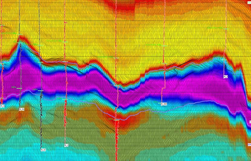
The main challenge for DTEK was that the interpretation from surface seismic of the top carbonate reservoir in the area of the M-55 well did not fit with the expected geological model. The surface seismic showed a very steep northern edge to the top carbonate, where geologically a gradual ramp had been expected. If the steep northern edge was correct, it would strongly impact future drilling targets and well planning. To make informed decisions, DTEK needed a better understanding of their subsurface geology.
The objectives of the survey included high resolution imaging along the top carbonate; obtaining accurate well-tie and velocity information at the well, including shallow velocity control to surface; and to record the amplitude variation with offset or AVO response of the top carbonate.
With these objectives in mind, RPS’ geophysicists performed pre-survey modelling, validating what is realistically achievable and optimising where possible. The VSPs were planned to provide high resolution imaging along the top carbonate to the north of M55 to resolve the conflict between the surface seismic image and expected geology. Securing shallow velocity control points for both Vp and Vs velocities would provide added value over legacy surveys.
For pre-survey planning, RPS geophysicists applied 3D modeling and considered subsurface geology, topography, and available equipment to optimise sources and receivers’ positioning. The modellers examined subsurface reflection coverage, angles and fold. The conclusion was to run several survey types to meet these objectives. These included a zero-offset source VSP for interval velocities and well tie and a range of offset and walk-away source VSPs for imaging laterally away from the well, particularly towards the north, and to obtain AVO information.
Once the modellers arrived at the ideal scenario, we began planning the physical acquisition. There is a trade-off between the ideal modelled acquisition plan and real-world constraints such as limited time, ground conditions, weather, and land access. RPS modellers, based in the UK, worked closely with the land survey team in Ukraine. The survey team was able to access the area around the wellsite in advance of the survey, and they checked that the modelled source locations worked in the field. As a final planning step, modellers took the recommended source positions from the land team and ran them back through the modelling.

Innovation in the planning stage included the recommendation of Avalon Sciences Geochain downhole equipment. This equipment consisted of a longer 12-level geophone array, rather than the 2-levels used on legacy surveys, which had standard 3-component geophones and a Gamma Ray included on the tool string. The longer array increased operational efficiency and provided more VSP data per unit time. RPS also recommended that different source locations be shot in one survey where possible, rather than every survey being acquired separately. This process is known as a flip-flop VSP, and can drastically reduce operational time.
During the survey planning stage, a unique collaboration of experienced VSP, wireline and seismic specialists were brought together. Each member of this group had key equipment and experience to complement and improve the VSP surveys. RPS delivered pre-survey modelling, planning and onsite quality control (QC). Downhole equipment from Avalon Sciences was hired, and Weatherford furnished the wireline. VSProwess provided software, modelling support and data processing. Also included in the team were local contractor surveyors with Vibroseis trucks.
In the field, unexpected swampy land made it impassable in places.
Changes had to be made to the acquisition plan once in the field.

Making use of extra rig time, DTEK also added two additional imaging objectives. New real-time modelling in the UK incorporated the field constraints and additional objectives and fed back information to the field team in Ukraine.
RPS’ QC specialists sent the data to VSProwess for processing on completion of the acquisition and QC. Processing was successfully completed within a short turn around time. Several advanced deliverables were produced, including high-resolution 2D seismic images (both Vp and Vs), local Vp and Vs velocities and well tie extending to surface.
Importantly, the surveys were acquired safely, with no major delays and no accidents or incidents reported.

The data revealed a gradual dipping of the northern flank of the structure. Compared to the surface seismic which indicated a steep northern edge of the top carbonate structure, it resolved the geological dilemma related to the depositional model of the field. With the updated geological model, DTEK re-assessed the plan to drill to the North of M-55, essentially preventing drilling a dry well, saving significant cost. The comparative cost to running the VSP surveys versus drilling a dry well is significant.
Additionally, the VSP data was used to assist the inversion of the surface seismic. Parameters derived from the inversion, allowed adjustments to be made to proposed well trajectories improving flow rates.
RPS’ collaborative approach and deep expertise in pre-survey modelling and seismic acquisition planning delivered a cost-effective and successful solution for DTEK.
This alternative option for VSP acquisition enabled greater flexibility in survey planning, operational efficiency improvements, and a step-change in data quality and resolution.

We delivered a flexible, cost-effective and successful solution that resulted in an updated geological model. Based on the improved model, DTEK avoided drilling a dry well, and made adjustments to proposed well trajectories which resulted in improved flow rates.

Energy transition

Energy transition


Energy transition


Principal Geophysicist - Team Leader

