
Aerial LiDAR and photogrammetry survey
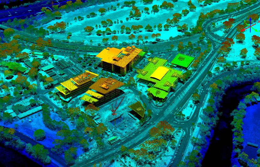
Light Detection and Ranging (LiDAR) is method of mapping that allows high levels of detail to be recorded about topography, vegetation, buildings, infrastructure, and more.
No Content Set
Exception:
Website.Models.ViewModels.Components.General.Banners.BannerComponentVm
Services
Technical services and consulting solutions for clients in the property, energy, transport, water, resources, defence and government sectors.
Advisory and management consulting
Communications, creative and digital
Design and development
Environment
Oceans and coastal
Planning and approvals
Project and program management
Water services
Advisory and management consulting
RPS advisory and management consulting services for businesses and projects, including economics, due diligence, transaction advisory, ESG and more.
Communications, creative and digital
Communications, creative and digital solutions for governments and businesses including community engagement, design, research, data and software development.
Design and development
Technical and consulting services for buildings, infrastructure and cities including architecture, engineering, surveying, landscape architecture and urban design.
Environment
Environmental consulting solutions for responsible, resilient and sustainable development including impact assessment, ecology and contamination management.
Oceans and coastal
RPS technical solutions for marine infrastructure and offshore development including coastal engineering, marine biology metocean science, and emergency response.
Planning and approvals
Development strategy, planning and approval solutions for buildings, infrastructure, transport and city projects and investments.
Project and program management
Project management solutions for the most complex building, infrastructure, organisational change, and systems projects.
Water services
Solutions for the water sector including quality monitoring, modelling, infrastructure design, engineering and asset management.
Sectors
World-leading technical and consulting solutions for clients in the property, energy, transport, resources, water, defence and government sectors.
Property
Energy
Transport
Defence and government services
Water
Resources
Property
Design, technical and advisory services for the property sector, including residential, commercial, retail, industrial, health, education and data centre projects.
Energy
Energy exploration, development and optimisation solutions for renewables, power and gas networks, energy storage, oil and gas and nuclear facilties.
Transport
Smart, safe and sustainable transport infrastructure development services and advice for rail, aviation, port and road clients and projects.
Defence and government services
Expertise for defence capability and infrastructure investments, security and safety projects, and information and telecommunications initatives.
Water
Discover our industry-leading strategy, design and management solutions for wastewater, groundwater, flooding, drainage and network infrastructure.
Resources
Commercial data, design advice and technical management solutions for safe and environmentally responsible resource exploration and operations.
Careers
Discover why RPS is a great place to build a great career
Careers in Australia and New Zealand
Careers in Australia and New Zealand
At RPS, every role provides an opportunity for you to grow your career within a collaborative, ideas-driven, and supportive culture.
Technical services and consulting solutions for clients in the property, energy, transport, water, resources, defence and government sectors.
Advisory and management consulting
Communications, creative and digital
RPS advisory and management consulting services for businesses and projects, including economics, due diligence, transaction advisory, ESG and more.
Project investment and finance
Business strategy and improvement
Explore Advisory and management consultingCommunications, creative and digital solutions for governments and businesses including community engagement, design, research, data and software development.
Creative, visualisation and immersive design
Data management, analytics and insights
Software design and implementation
Explore Communications, creative and digitalTechnical and consulting services for buildings, infrastructure and cities including architecture, engineering, surveying, landscape architecture and urban design.
Environmental consulting solutions for responsible, resilient and sustainable development including impact assessment, ecology and contamination management.
Contaminated land and remediation
Environmental Impact Assessment
Environmental permitting and compliance
Sustainability and climate resilience
Explore EnvironmentRPS technical solutions for marine infrastructure and offshore development including coastal engineering, marine biology metocean science, and emergency response.
Commercial fisheries advice and services
Marine site investigation and geoscience
24/7 response modelling and support services
Marine life mitigation - PSOs, MMOs and PAM
Metocean, Science and Technology
Explore Oceans and coastalDevelopment strategy, planning and approval solutions for buildings, infrastructure, transport and city projects and investments.
Project management solutions for the most complex building, infrastructure, organisational change, and systems projects.
Cost management / quantity surveying
Explore Project and program managementSolutions for the water sector including quality monitoring, modelling, infrastructure design, engineering and asset management.
Water quality modelling and monitoring
Explore Water services
World-leading technical and consulting solutions for clients in the property, energy, transport, resources, water, defence and government sectors.
Design, technical and advisory services for the property sector, including residential, commercial, retail, industrial, health, education and data centre projects.
Energy exploration, development and optimisation solutions for renewables, power and gas networks, energy storage, oil and gas and nuclear facilties.
Smart, safe and sustainable transport infrastructure development services and advice for rail, aviation, port and road clients and projects.
Expertise for defence capability and infrastructure investments, security and safety projects, and information and telecommunications initatives.
Organisational strategy and change
Explore Defence and government servicesDiscover our industry-leading strategy, design and management solutions for wastewater, groundwater, flooding, drainage and network infrastructure.
Commercial data, design advice and technical management solutions for safe and environmentally responsible resource exploration and operations.
We define, design and manage projects that create shared value to a complex, urbanising and resource-scarce world.
Brilliant minds finding solutions to complex problems, made easy to understand. Making complex easy.

Our aerial mapping team was engaged by Victoria's Department of Environment, Land, Water and Planning (DELWP) to undertake LiDAR capture for the entire metro area at a high point density of eight points per square metre.
The project utilised multiple aircraft during several stages to support successful data capture under tight urban flight restrictions close to Tullamarine Airport. Despite the challenging conditions flying over a metropolitan area with busy airspace, we were able to collect all data and deliver a high-quality dataset to DELWP.
The project was the winner of the 2019 Victorian regional Asia Pacific Spatial Excellence Awards and was delivered on budget, with the client using the high point density dataset to derive a wide range of insights for the city.
3D model developed from LiDAR data of the iconic Melbourne Cricket Ground (MCG).
